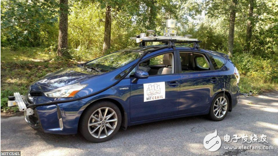
On May 7th, according to Forbes magazine, the Massachusetts Institute of Technology (MIT) developed a new system that allows driverless cars to navigate without a map. This nascent technology may be used to help prevent future traffic accidents, such as the recent death of Uber unmanned vehicles. Let's take a look at the relevant content. MIT develops new technologies: driverless cars can navigate without maps: MIT's laboratory CSAIL equips the unmanned Toyota Prius with a new system that can be used on country roads? So far, many unmanned vehicles tested on real roads either rely on highly detailed 3D maps or the system allows vehicles to navigate in well-defined urban or highway environments. But most American highways have not been accurately mapped to three-dimensional maps, or they cannot reliably provide consistent lane markings. As a result, the MIT Computer Science and Artificial Intelligence Laboratory (CSAIL) research team developed a methodology that allows driverless cars to read and predict the local environment rather than relying on 3D map data. MIT develops new technology: driverless cars can navigate without maps Called MapLite, this framework combines the Global Positioning System (GPS) with the most basic topographic maps from OpenStreetMap and lidar and IMU sensors for monitoring road conditions. Teddy Ort, a CSAIL graduate student, said: "This 'no map' model has never been tried before because it is often difficult to have the accuracy and reliability of a detailed map. Systems like this can be Navigation on the in-vehicle sensor shows the potential of a driverless car that can cope with road conditions beyond the maps drawn by technology companies." The researchers drafted a report describing the system, which will be presented later this month at the International Conference on Robotics and Automation (ICRA) in Brisbane, Australia. To test the system, the researchers equipped the unmanned Toyota Prius with laser radar, sensors and MapLite. The Prius was able to "see" the road 30 meters ahead and successfully traveled on several unpaved country roads in Massachusetts. The researchers said in the report: "This means that it can drive cars at speeds of more than 100 kilometers per hour, and if the method can be parallelized and implemented on the GPU, the car may travel faster." Olt explained that their system is also different from other "no map" models, which use machine learning to train the system. They use data from a set of roads, then test their patterns and apply them to other roads. Instead, MapLite tries to develop a model of what a driver can experience, and then tells it how it behaves, which is not much different from how a human driver can drive in a familiar scene. “At the end, we want to be able to ask the car more questions, such as 'How many roads are being merged at this crossroads?' By using modeling techniques, we can better better if the system is not working or an accident occurs,†said Oort. Understand the reasons." While systems like MapLite can open up more directions for the development of driverless cars, it still has a long way to go. Researchers say their systems can't explain the changes in altitude, so they can't cope with the mountain now. “I think that future driverless cars will always use 3D maps in urban areas, and when we are driving on remote roads in the country, these vehicles need to behave like humans on unfamiliar roads,†said Oort. In response, we hope that our efforts will take a big step in this direction." Crystal Clear Back Sticker,Phone Sticker,Mobile Phone Back Skin,Crystal Clear Phone Skin Shenzhen Jianjiantong Technology Co., Ltd. , https://www.jjthydrogelmachine.com